Today, 29 July 2025, a new SA Weather alert confirms fine and cool conditions across most of South Africa. The South African Weather Service (SAWS) expects clear skies, dry air, and chilly morning temperatures in several provinces. The cool weather offers some relief after recent cold fronts and rain.
You can enjoy a pleasant day in most regions, but it’s still winter, so wrap up warmly and keep sunscreen close, especially where UV levels stay high.
ALSO READ: Cold Front Hits Gauteng: Icy Temperatures and Partly Cloudy Skies Set to Continue
What You Can Expect in Your Province
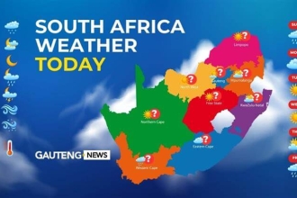
Gauteng
You can expect fine and cool conditions with clear skies and cold morning temperatures. The UVB sunburn index remains high. If you’re going outside, apply sunscreen even though it’s winter.
Mpumalanga & Limpopo
Both provinces will see dry weather and cold to cool air. If you live in a high-lying area, you may feel an extra chill in the early hours.
North West & Free State
Expect stable weather with light winds and crisp air. The southeastern parts of the Free State may wake up to frost. The rest of the day stays cool but sunny.
Northern Cape
Weather conditions vary here. The coastal areas stay cool, while isolated showers may reach the northeastern part. Windy conditions will continue inland, so prepare for some gusts.
Western Cape
Morning fog will cover parts of the province, especially in the west. Inland areas will clear up and warm slightly later in the day. Fog might return by evening in the northwest. Fire danger remains extremely high in parts like Swellendam and Hessequa.
Eastern Cape
The western part of the province stays cool and dry, while the coast warms up slightly. The eastern half will also experience fine and cool conditions, especially away from the coast.
KwaZulu-Natal
KZN will experience cold weather, but skies will remain clear. The UVB index is very high, so take sun safety seriously even if it’s chilly.
SA Weather Alert Summary – 29 July 2025
- Fine and cool conditions across most of the country
- Cold mornings expected in Gauteng, Free State, and Northern Cape
- Very high UVB index in Gauteng and KZN
- Isolated showers possible in parts of the Northern Cape
- Fire danger is high in some Western Cape regions.
Why This Weather Alert Matters
Even though conditions are mostly stable, today’s SA Weather alert helps you plan better. Cold temperatures in the morning mean you should wear layers, especially if you work outside or travel early.
If you live in fire-prone areas of the Western Cape, stay alert. Dry vegetation and strong inland winds increase fire risk. Farmers should also protect livestock from early morning frost in the Free State and parts of the Northern Cape.
Quick Tips for Today’s Weather
- Wear layers; mornings are cold.
- Use sunscreen. UV levels remain high.
- Check for fog if you drive early or late.
- Watch for fire warnings in Western Cape
- Wrap up outdoor tasks before sunset.
Outlook for the Week
Weather patterns show no major changes for the next few days. Expect more fine and cool conditions across most provinces. Inland areas will continue to see chilly mornings, while coastal provinces might get light showers and cloud cover later in the week.
CHECK OUT: Today’s Weather Forecast – 29 July 2025
This SA Weather alert signals calm, dry weather for much of South Africa. The clear skies offer a break from the rain and cold fronts seen earlier this month. However, the cold mornings and UV exposure still call for caution.
Dress warmly, stay informed, and enjoy the fine winter weather safely.