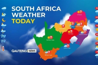
Severe Weather Alert: Severe Thunderstorms in Limpopo
South Africa is bracing for a series of severe weather events on Tuesday, 25 February 2025, as the South African Weather Service (SAWS) issues warnings for thunderstorms, flooding, and damaging winds across multiple provinces. Residents in Limpopo, KwaZulu-Natal, and the Western Cape are urged to take necessary precautions as extreme weather conditions could lead to localized damage and disruptions.
Severe Thunderstorms and Flood Risk in Limpopo
A yellow level 2 warning has been issued for severe thunderstorms expected over the northern and central parts of Limpopo. These severe thunderstorms will bring:
✅ Heavy downpours – Potentially causing localized flooding on roads and in low-lying areas.
✅ Damaging winds – Increasing the risk of falling trees and infrastructure damage.
✅ Excessive lightning and hail – Threatening both property and personal safety.
Residents are advised to stay indoors during thunderstorms, avoid flooded roads, and secure loose outdoor objects that could be blown away by strong winds.
Flooding Threat in KwaZulu-Natal
KwaZulu-Natal (KZN) is at risk of disruptive rain, particularly in the extreme northeastern parts of the province. Another yellow level 2 warning has been issued, with expected impacts including:
🌊 Localized flooding in both formal and informal settlements.
🚧 Road and bridge closures due to excessive water levels.
🏠 Structural damage to vulnerable infrastructure.
Heavy rainfall has already saturated parts of KZN, and the additional rain could worsen conditions. Motorists should drive cautiously, avoid crossing flooded areas, and seek alternative routes where necessary.
Strong Winds in the Western Cape
The Western Cape is facing damaging winds along the coastline, particularly between Lambert’s Bay and Cape Point, extending to Cape Agulhas in the afternoon. These winds could result in:
🚢 Difficulty in navigation at sea, posing risks to small vessels and fishermen.
🌊 Rough seas and high waves, increasing the potential for coastal flooding.
🌲 Falling branches and power line damage, leading to possible electricity disruptions.
Residents along the coast should secure outdoor items, avoid unnecessary travel, and stay updated on weather advisories.
Fire Danger Warnings in Northern Cape and Western Cape
In addition to the severe weather threats, extremely high fire danger conditions have been declared in:
🔥 Hantam, Khai-Ma, and Karoo Hoogland municipalities (Northern Cape).
🔥 Cederberg and the City of Cape Town municipalities (Western Cape).
Dry and windy conditions increase the risk of wildfires, which can spread rapidly. People are urged to:
✔️ Avoid starting open flames in high-risk areas.
✔️ Report any signs of wildfires immediately to local authorities.
✔️ Follow evacuation procedures if instructed by emergency services.
Provincial Weather Forecast for 25 February 2025
Here’s a breakdown of what to expect across the country:
Gauteng
☀️ Partly cloudy and warm with a high UV index. Residents should take sun protection measures.
Mpumalanga
☁️ Cloudy in the east with morning fog along the escarpment.
🌧️ Isolated showers and thundershowers, except in the extreme southwest.
Limpopo
☁️ Cloudy in the east with morning fog patches.
⛈️ Isolated to scattered showers and thundershowers expected.
North West
☁️ Cloudy and cool to warm with isolated showers and thundershowers.
Free State
🌥️ Partly cloudy and warm to hot, with isolated showers and thundershowers in the west.
Northern Cape
☀️ Clear skies along the coast but partly cloudy and hot inland.
🌧️ Isolated showers and thundershowers in the east.
Western Cape
☀️ Fine in the western parts.
🌧️ Cloudy and warm to hot with light rain along the south coast.
Eastern Cape
(Western half) ☁️ Cloudy and cool, with widespread rain along the coast.
(Eastern half) ☀️ Fine in the north initially, becoming partly cloudy with scattered showers.
KwaZulu-Natal
☁️ Cloudy conditions in the morning with fog over the interior.
🌧️ Scattered showers and thundershowers, more frequent in the northeast and southern parts.
Safety Precautions and Final Thoughts
With severe thunderstorms, flooding, strong winds, and fire risks impacting various provinces, residents are urged to stay informed and take necessary precautions:
✔️ Stay indoors during thunderstorms and heavy rain.
✔️ Avoid unnecessary travel in flooded or high-wind areas.
✔️ Secure loose objects that could be carried away by strong winds.
✔️ Follow updates from SAWS and local authorities for emergency alerts.
South Africa’s changing climate means that extreme weather events are becoming more frequent. Staying prepared and vigilant can make a significant difference in reducing damage and ensuring safety.
Stay safe and keep an eye on the latest weather updates!


