Brace for a wintry blast as snow, freezing temperatures, and disruptive weather sweep across South Africa this week.
Winter’s Early Arrival
South Africa is bracing for an unseasonal cold snap this week as a powerful cold front brings icy temperatures, snow, and severe weather conditions across multiple provinces. The South African Weather Service (SAWS) has issued several warnings, including a Yellow Level 4 alert for damaging winds and waves in the Western Cape, signalling the onset of a significant weather event.
Snowfall and Freezing Temperatures Forecasted
- Temperatures are projected to drop slightly below zero degrees Celsius, especially in the central and southern regions, as well as areas along the Lesotho border.
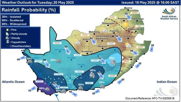
- Starting Tuesday, the cold front is expected to sweep across South Africa, bringing a significant drop in temperatures.
- Snowfall is anticipated over the Drakensberg mountains in Lesotho and in high-altitude regions of KwaZulu-Natal and the Eastern Cape.
- The Free State is also on high alert, with the first frost of the season expected in some areas.
Severe Weather Warnings Issued
SAWS has issued multiple warnings in anticipation of the severe weather conditions:
- Yellow Level 4 Warning: Damaging winds and waves are expected along the Western Cape coastline, with strong to gale-force north-westerly and westerly winds.
- Yellow Level 2 Warning: Severe thunderstorms are anticipated over the north-eastern parts of the Northern Cape, and disruptive rain over the southern parts of Mpumalanga.
These conditions pose risks such as uprooted trees, damage to infrastructure, hazardous driving conditions, and potential flooding.
Travel and Safety Advisories
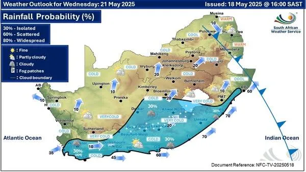
- Motorists are advised to exercise extreme caution when travelling through mountainous regions and high-altitude passes.
- The N3 toll route (connecting Johannesburg and Durban) is particularly vulnerable to snowfall and may experience temporary closures.
- Snow and icy conditions may lead to dangerous driving scenarios, so non-essential travel is discouraged.
- Check weather updates before travelling and ensure emergency supplies are in the vehicle, such as blankets, water, and first aid kits.
Public Health and Safety Measures
Acting Minister of Cooperative Governance and Traditional Affairs, Kubayi, has emphasised the importance of public safety during this cold front. Residents are advised to dress warmly, cover their mouths in extreme cold to protect their lungs, and avoid consuming alcohol and caffeinated drinks, which can increase the risk of hypothermia.
Special attention should be given to vulnerable populations, including the elderly and young children. Communities are encouraged to check on neighbours and ensure everyone has adequate shelter and warmth.
Impact on Agriculture and Livestock
Farmers are advised to take precautionary measures to protect crops and livestock from the impending cold. The anticipated frost poses a risk to agriculture, particularly to crops sensitive to low temperatures. Implementing frost protection measures, such as covering crops and ensuring adequate shelter for livestock, is crucial during this period.
Regional Weather Outlook for All 9 Provinces
Gauteng:
- Partly cloudy with cool temperatures.
- Light showers expected in the southern parts.
- Cold evenings are anticipated; motorists should be cautious of icy patches.
KwaZulu-Natal:
- Snowfall expected in high-altitude areas such as the Drakensberg mountains.
- Heavy rainfall and strong winds in coastal regions.
- Road closures may occur in snowy regions; travel with caution.
Western Cape:
- A Yellow Level 4 warning is in place for damaging winds and rough seas.
- Gale-force winds expected along the coast.
- Cold and rainy conditions throughout the province, with localized flooding possible.
Eastern Cape:
- Snowfall expected in high-lying areas.
- Cold and wet conditions across much of the province.
- Travelers are advised to avoid mountainous routes during heavy snow.
Free State:
- Anticipated frost with temperatures below zero in some areas.
- Snow may impact parts of the Lesotho border region.
- Farming communities are advised to protect crops and livestock.
Northern Cape:
- Cold and dry conditions with strong winds in the Namakwa District.
- Disruptive winds may affect transportation and cause power outages.
- Motorists should beware of blowing dust and reduced visibility.
Limpopo:
- Cool and partly cloudy with isolated showers in the southern regions.
- Temperatures expected to drop sharply towards midweek.
- Roads may become slippery due to light drizzle.
Mpumalanga:
- Cold weather with isolated thundershowers anticipated.
- Frost warnings for the Highveld regions.
- Motorists should be cautious of fog and low visibility in the mornings.
North West:
- Cool to cold with partly cloudy skies.
- Light showers expected in western parts of the province.
- Farmers are urged to take precautionary measures against frost.
Stay Informed and Prepared
Residents are encouraged to stay updated with the latest weather forecasts and advisories issued by the South African Weather Service. Taking proactive measures can significantly reduce the risks associated with severe weather conditions.
For more information and real-time updates, visit the SAWS website or follow their official social media channels.
Also read: Today’s Weather Forecast – 19 May 2025

